Introduction
The West African Monsoon is a label used to describe the seasonal variation in rainfall and prevailing wind direction for more than a dozen countries in West Africa. The monsoon is driven by two jet streams, the African Easterly Jet (AEJ) and the Tropical Easterly Jet (TEJ). The position of both jet streams affects the balance of the air masses, and has a huge bearing on smaller-scale physical processes within the atmosphere, such as the rate of convection. In stark contrast, both jet streams are heavily influenced by the position of the Intertropical Convergence Zone (ITCZ). This can be summarised as the near-equatorial point at which the northeasterly trade winds and southeasterly trade winds converge. This fluctuates north-south bi-annually.
There are two air masses which determine the weather conditions – also known by Quantities of Interest QoI’s of West Africa. Namely, the Saharan Heat Low (SHL), which sits in the north of the region, is characterised by hot air – warmed through solar insolation, that rises up rapidly through the troposphere, diverging at upper levels, to the Mediterranean High and the Gulf of Guinea. A particularly intense SHL will reinforce the south-westerly monsoon flow along its eastern flank, and the north-easterly Harmattan flow along the western flank, allowing for convection along the coast of the Gulf of Guinea, meanwhile inhibiting most convection over Senegal (Lavaysse, C. et al). This is supported by a simple diagram below showing the counter-clockwise flow of the SHL.
The other air mass is a cooler, denser, oceanic air mass which is situated over the Gulf of Guinea. In the Atmospheric Boundary Layer (ABL), the Gulf of Guinea moderates the moisture convergence, and therefore the variation in temperature. To completely understand the ocean-atmosphere processes involved, it is a prerequisite to know the annual cycle of rainfall patterns in West Africa. For example, the dramatic shift in QoI’s (rainfall, wind direction, humidity) for any regions further north than 12-14°N during the winter.
The Intertropical Discontinuity (ITD), is the formal name for the point at which both of these air masses meet (M. Fischer et al).
Saharan Heat Low – a more detailed overview
The SHL is a classified as a thermal low-pressure system (thermal low) that develops through the intense solar heating of the Sahara Desert’s dry, sandy surface during the boreal summer. Such insolation over a surface with a low heat capacity creates extreme temperature spikes in the region. For example, Timbuktu, Mali, maximum temperatures beyond 45°C have been observed June through September whilst lows plunge to 10C or below during the dry season. Consequently, living in the Sahara is considered inhospitable to many, but what about the Sahel or even closer towards the Gulf of Guinea coastal regions?
Well, in these locations, in the ABL, the air will converge towards the Saharan Heat Low, with sea breezes onshore. This leads to more consistent rainfall and convection throughout the year, less parched soil / drought. Hence, higher populations are found further south, where conditions are conducive to farming. As this figure, from Nasa’s Black Marble (https://eoimages.gsfc.nasa.gov/images/imagerecords/90000/90008/earth_vir_2016_lrg.jpg) shows more city lights closer to the Atlantic Coast (Gulf of Guinea).
Mechanics
Alike to other thermal lows, as the hot air rises, it will cool according to the dry adiabatic lapse rate, diverging aloft. In order to replace the rising air, in the lower troposphere, air from nearby higher pressure (surrounding areas) will flow inwards towards the low-pressure centre. This converging air (near the ABL), is deflected by the Coriolis force, resulting in a counter-clockwise rotation of the SHL. The SHL will also have sub-geostrophic winds as a result, allowing the air to flow inwards toward the low – after taking into account the anticlockwise motion. The converging winds (pressure gradient force [PGF]) and Coriolis force are equated in the equation below.

PGF = RHS of the equation.
Coriolis Force = LHS of the equation.
In addition to the converging and diverging air, the SHL is unique by virtue of the fact that there is strong vertical mixing in the lower atmosphere, which helps distribute heat upward. This process is enhanced by a lack of moisture in the region – dry air will heat and cool more efficiently than humid air. Additionally, the rising air over the SHL invokes turbulence. Clear air turbulence (CAT) in particular is a challenge for pilots facilitating air travel over the region, given that it cannot be detected. Numerous cases of CAT have caused in-flight casualties, has often reported by the media.
The strength of the SHL also impacts the African Easterly Jet (AEJ) – where the temperature and rate at which the air diverges out of the top of the SHL correlates to the intensity of the AEJ.
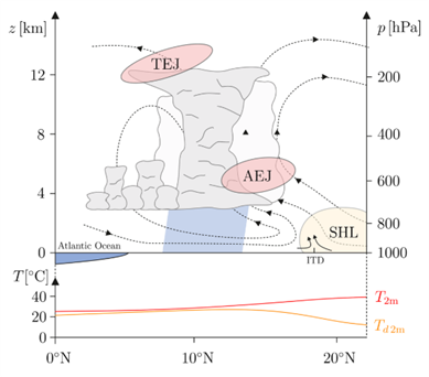
Figure from (M.Fischer et al.)
The AEJ also shifts in position according to the Saharan Heat Low, where any land south of the AEJ will experience rainfall. Hence, in the summer, the AEJ will be stronger and further north – more frequent African Easterly Wave’s (AEW’s) will travel westward along the AEJ, initiating and organising mesoscale convective systems – which can mature into hurricanes over the Atlantic with notably strong AEW’s. The stronger the AEJ is, and SHL is, the more vertical sheer there is over West Africa in the summer months, this helps to prolong the longevity of MCSs / squall lines – heavy rainfall events have are being increasingly observed south of the Sahel region. The SHL is an important air mass in the WAM since both its current behaviour and future behaviour will with medium confidence (IPCC, 2021), increase the late-season NH summer rainfall receives.
Future Projections (IPCC)
Diagram to the left from IPCC AR6
More generally, the West African Monsoon has already been affected by climate change (since the early-mid 20th century) with respect to alterations of various climatic impact drivers (CID). Coastal flooding is such a CID that is very likely to virtually certain to continue, and worsen during the 21st century – due to higher SSTs – 7% more moisture for every degree of temperature rise (IPCC, 2021). Alongside precipitation, average wind speeds are projected to strengthen in the region. This may facilitate green energy solutions such as wind turbines which will have a positive impact on the climate. Precipitation is also projected to increase, although the IPCC have tagged this with medium confidence, there are limited observation stations in West Africa, so further developments need to happen to ascertain projections of QoIs. Better observations will help reduce uncertainties with weather models such as the Icosahedral Non-Hydrostatic (ICON) model.
End/Conclusion
Through the Saharan Heat Low, it is fairly conclusive that the West African Monsoon is projected to herald worse impacts for West Africa, such as heavy rainfall (from higher SSTs), and a higher humidity leading to exacerbated impacts from extreme bursts of heavy rain. The Harmattan winds were also referred to above. The intensification of the SHL, will make the Harmattan’s stronger, and the effect that they have on West Africa – particularly westernmost countries – hot and dry conditions will only cause more frequent droughts.
Together, the heavy rainfall and extreme drought conditions will turn the monsoon season from being a reliably safety net for farmers in the region, into a volatile system, easily influenced into extremes by other climatic impact drivers across the world. Ultimately, the most prominent risk of the West African Monsoon lies within the irregularities brought on through rising SST’s and the impact that has on the MCSs. Not all hope is lost however, as the ITCZ, has been gradually shifting northwards throughout the 21st century, allowing rainfall to penetrate further northwards into the Sahel, bringing higher rainfall totals to countries that would otherwise receive sparse amounts. This is a positive impact which has not been predicted (Aumann Et Al.), increasing hope but reducing confidence from IPCC as to how the WAM will evolve into the future.
Bibliography
- Aumann, H. H., Broberg, S., & Manning, E. M. (2024). Northward shift and narrowing of the ITCZ in 20 years of AIRS data. Journal of Geophysical Research: Atmospheres, 129, p.1, E2023jd038723 https://doi.org/10.1029/2023JD038723 (Accessed: 21 January 2025).
- Fischer, M., Knippertz, P., van der Linden, R. Lemburg, A., Pante, G., Proppe, C., and Marsham, J. H.: Quantifying uncertainty in simulations of the West African monsoon with the use of surrogate models, Weather, Clim. Dynam., 512, https://doi.org/10.5194/wcd-5-511-2024, 2024 (Accessed: 1 February 2025).
- Intergovernmental Panel on Climate Change (IPCC) (2021) Climate Change 2021: The Physical Science Basis. Contribution of Working Group I to the Sixth Assessment Report of the Intergovernmental Panel on Climate Change. Edited by Masson-Delmotte, V., Zhai, P., Pirani, A., Connors, S.L., Péan, C., Berger, S., Caud, N., Chen, Y., Goldfarb, L., Gomis, M.I., Huang, M., Leitzell, K., Lonnoy, E., Matthews, J.B.R., Maycock, T.K., Waterfield, T.,Yelekci, O., Yu, R. and Zhou, B. Cambridge: Cambridge University Press. Available at: https://www.ipcc.ch/report/ar6/wg1/ (Accessed: 5 February 2025).
- Lavaysee, C., Flamant, C., Janicot, S. et al. (2009) Seasonal evolution of the West African heat low: a climatological perspective. Available at: https://doi.org/10.1007/s00382-009-0553-4 (Accessed: 7 February 2025).